


Types of cloud
Meteorologists classify clouds mainly by their height and shape, and often combine two descriptive terms into a complex name such as cirrostratus or stratocumulus.
Height
High clouds (cloud base between 6 and 12 km) is called cirrus or is given the prefix cirro-.
Medium cloud (cloud base between 2 and 6 km) is given the prefix alto-.
Low cloud is usually classified by its shape, with no special prefix.
Shape
Clouds which are generally flat are described as stratus or are given the prefix strato-.
Clouds which are towering or puffy are described as cumulus or are given the prefix cumulo-.
Other words
Rain-producing clouds are described as nimbus or given the prefix nimbo-.
Clouds which appear to have been broken up by wind are given the prefix fracto-.
|
|
| Cirrus: very high wisoy clouds formed of ice crystals |

|
|
| Cirrostratus:high sheets of thin ice cloud, often producing a halo effect around the sun or moon |
|
|
| Altostratus: layer if almost unbroken cloud at medium height |
|
|
| Altocumulus: fairly high ‘woolly’ looking cloud. |
|
|
| Stratus: almost continuous sheets of low cloud; often grey and associated with drizzle. |
|
|
| Cumulus: low, puffy clouds. Sometimes white and assoiated with fair weather but may grow upwards, produce showers and take on some of the characteristics of cumulonimbus. |
|
|
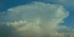
| Cumulonimbus: the classic ’thundercloud’, with a fairly low cloud base but very high top (often flat): it may be up to 4-5 km from top to bottom. Its great height is caused by rising air currents inside the cloud, which allow large raindrops or hail to develop. |
|
|
| Nimbostratus: low, heavy looking shets of grey cloud, associated with continuous rain (e.g. at a warm front). |
|
|
| Fractostratus: very low, ragged clouds associated with wet and windy weather. |
|
|
| Stratocumulus: an apparently contradictory name applied to cumulus clouds that have spread out and combined to form a broken sheet, or to thin stratus that appears to be breaking up into separate clouds. |